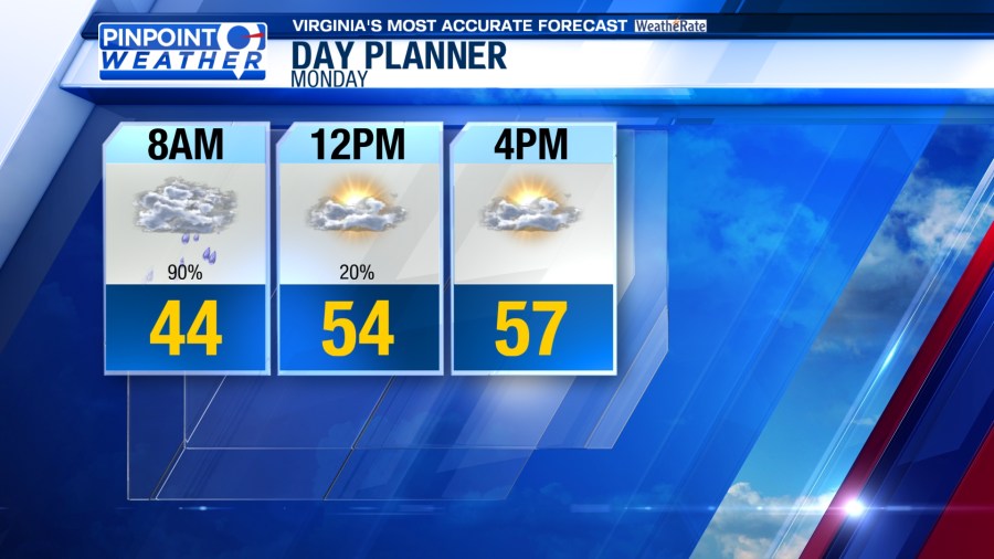
ROANOKE, Va. (WFXR)—Southwest and Central Virginia can expect soggy conditions on Monday morning. While drier conditions are anticipated late in the day, more precipitation is ahead for the week.
A widespread band of rain will move through the region Monday morning, so use caution on wet roadways during the morning commute. Most of the rain activity should move toward the east by the afternoon. Late-day sunshine is possible with temperatures rising into the 50s and lower 60s.

Tuesday will start with morning temperatures in the lower/middle 40s under mostly cloudy skies. Highs will be in the upper 50s and lower 60s. Some showers are possible during the day, but there’s a greater chance of rain during the late afternoon and evening hours.


A cold front will arrive on Wednesday. Rain will remain in the forecast and winds will become gusty. These winds will carry much cooler air into the region, causing temperatures to drop throughout the day. Morning temperatures will be in the upper 40s and 50s, but afternoon temperatures will likely be in the 30s and 40s. The falling temperatures will allow rain to change to snow toward the mountains.


Although more sunshine is in the forecast, prepare for a cold and windy Thursday. Morning lows will be in the sub-freezing 20s, but wind chill values in the single digits may occur along and west of the Blue Ridge. Afternoon temperatures will reach the upper 20s and 30s.

High pressure will keep Southwest and Central Virginia dry and mostly clear on Friday. Morning temperatures will start in the frigid teens and 20s while afternoon highs will be in the chilly 30s and 40s.
Another storm system could bring rain showers to the region late Saturday into Sunday.